Introduction
Accurate and reliable positioning information is essential in today's connected world, whether for outdoor adventures, drone operations, or asset monitoring. The Loko GPS Tracker integrates multiple satellite navigation systems—GPS, GLONASS, and GALILEO—to deliver enhanced positioning performance across diverse conditions and geographic regions.
Understanding Global Navigation Satellite Systems
Modern positioning relies on satellite constellations orbiting Earth, continuously broadcasting signals that receivers use to calculate precise locations. The Loko GPS Tracker accesses three independent systems simultaneously:
GPS (Global Positioning System)
Developed by the United States Department of Defense, GPS revolutionized navigation when it became fully operational in 1995. The system consists of 32 satellites distributed across six orbital planes at approximately 20,000 kilometers altitude.
GPS is described as "the most utilized satellite navigation system globally," providing positioning accuracy of 5-10 meters under normal conditions. The system operates on two civilian frequencies (L1 and L5) and secure military frequencies.
GLONASS (Global Navigation Satellite System)
Created by Russia, GLONASS was initially developed for military applications but now provides commercial positioning services worldwide. The system features 24 satellites across three orbital planes.
GLONASS satellites orbit at slightly different altitudes than GPS, providing complementary coverage that improves positioning reliability, particularly at high latitudes where GPS coverage may be less optimal.
GALILEO
The European Union's GALILEO system represents the newest global navigation constellation. When fully operational with its planned 30 satellites, GALILEO will provide highly accurate civilian positioning services.
GALILEO provides more accurate positioning services at higher latitudes, filling gaps where other systems may have reduced satellite visibility. The system offers both free open-service signals and commercial encrypted signals for premium applications.
Advantages of Multi-System Integration
Accessing multiple satellite systems simultaneously delivers significant benefits:
1. Enhanced Coverage
With satellites from GPS, GLONASS, and GALILEO all available, receivers can access far more satellites at any given time. This abundance means:
- Improved satellite visibility in challenging environments (urban canyons, forests, mountains)
- More consistent positioning in locations where individual systems have gaps
- Faster initial position acquisition when powering on the device
2. Improved Accuracy
Multi-constellation receivers combine data from all available satellites across different systems. This approach delivers "increased accuracy and data integrity" through:
- Better geometric diversity of satellite positions
- Redundant measurements that help identify and eliminate errors
- More robust position calculations even when some satellites have degraded signals
3. Research Applications
Beyond basic positioning, multi-system receivers enable advanced applications including:
- Ionospheric monitoring and atmospheric research
- Precise timing for scientific instrumentation
- Geodetic surveys and earth science studies
Loko GPS Tracker: Multi-System Implementation
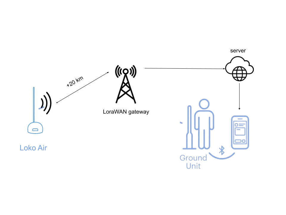
The Loko GPS Tracker leverages all three satellite systems alongside advanced radio communication:
Technical Specifications
- Satellite Support: GPS, GLONASS, and GALILEO integration
- Communication: LoRa P2P and LoRaWAN radio capabilities
- Range: Exceeding 5 kilometers in optimal conditions
- Battery Life: Up to 1 year on a single charge, depending on transmit interval
- Construction: Water, dust, and crash-resistant design
- Form Factor: Compact, lightweight design (12 grams, 30 x 23 mm)
Practical Benefits
This multi-system approach ensures the Loko tracker performs reliably across diverse scenarios:
- Consistent tracking in dense forests where tree canopy blocks some satellites
- Reliable positioning in urban environments with tall buildings
- Accurate location data at high latitudes where GPS alone may be suboptimal
- Faster position fixes when first powering on the device
Target Applications
Outdoor Activities and Adventure Sports
Hikers, climbers, and backcountry enthusiasts benefit from reliable positioning even in challenging terrain. The multi-satellite approach ensures consistent tracking in deep canyons, dense forests, and high-altitude environments.
Drone Integration and Protection
Drone operators attach the lightweight Loko tracker to aircraft for real-time flight monitoring and recovery after crashes. Multi-system positioning provides accurate location data even when flying in areas with limited satellite visibility.
Asset and Possession Tracking
Businesses and individuals track valuable equipment, vehicles, and personal items. The combination of satellite positioning and LoRa communication provides reliable tracking without expensive monthly subscriptions.
IoT Network Integration via LoRaWAN
The Loko tracker integrates with existing LoRaWAN networks, enabling large-scale deployments for agricultural monitoring, fleet management, and smart city applications.
The Future of Multi-Constellation GNSS
As satellite navigation systems continue evolving, multi-constellation receivers will become increasingly important:
- Additional regional systems (BeiDou, QZSS, NavIC) further enhance coverage
- New satellite signals provide improved accuracy and interference resistance
- Advanced receivers integrate multiple frequencies for centimeter-level precision
Conclusion
The Loko GPS Tracker's integration of GPS, GLONASS, and GALILEO satellite systems delivers superior positioning performance compared to single-system devices. This multi-constellation approach ensures reliable tracking across diverse environments and conditions, from urban centers to remote wilderness.
Combined with LoRa radio technology for extended-range communication, rugged construction for harsh environments, and extended battery life for continuous operation, the Loko tracker provides a comprehensive solution for applications ranging from outdoor recreation to professional asset management.
Whether you're exploring backcountry trails, protecting drone investments, or managing business assets, multi-system satellite positioning ensures you can trust your tracking data when it matters most.